Wheel Deal Details
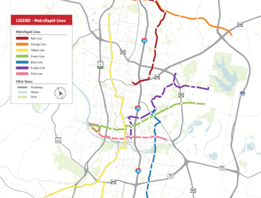
Orange Line Light Rail
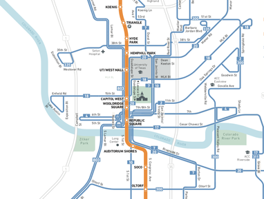
Light Rail from Tech Ridge to Slaughter Lane running on North Lamar, Guadalupe, and South Congress.
Cost
$3.177 billion
What this is
This is the much-awaited high-capacity transit spine Austin needs as a foundation to a widely-used system.
Why this is in the plan
Orange Line light rail is both good transit and good politics.
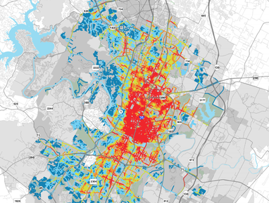
The Orange Line runs through the region's highest ridership transit corridor and has the potential to produce the most significant ridership increases while efficiently using scarce operating funds.
Orange Line light rail is also Austin's most well-known and popular high-capacity transit project with grassroots transit activists and many community leaders.
The combination of Orange Line light rail with our ambitious land acquisition fund represents a meaningful investment in permanent affordability that will help house and transport thousands of Austinites, while also helping to reduce the City's carbon footprint.
Cost estimate methodology
The Orange Line cost estimate is based on Project Connect's Orange Line Capital Cost Estimates from October of 2019.
Cost estimates for the downtown transit tunnel and new support facilities are from Project Connect's Joint Work Session presentation from October of 2019.
The surfarce Orange Line LRT estimate provided by Project Connect is $3.8 billion. We assume a 40% match from the Federal Transportation Administration's transit infrastructure grant program.
The expected local share is roughly $2.28 billion. In addition, we added $802 million as the Orange Line's share of the downtown transit tunnel and $95 million as its share of the needed support facility upgrade.
Policy requirements
Leverage the proposed land acquisition fund to generate dedicated operating revenue for the Orange Line.
Plan the sequencing of the Orange Line's construction in coordination with 2018 Affordable Housing Bond projects and land acquisition fund investments to protect housing affordability near its stations.
Ensure transit-supportive residential and commercial entitlement density within walking distance from planned stations.
Coordinate Orange Line construction with Corridor Mobility projects to support additional bicycle and pedestrian infrastructure, as well as to ensure cost-effectiveness.
Resources for further reading
Blue Line Light Rail
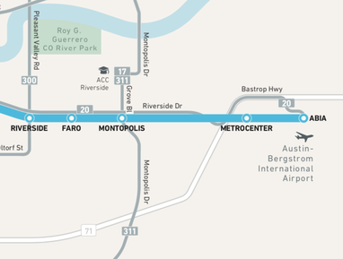
Light Rail from Airport to central Austin running on East Riverside.
Cost
$1.171 billion
What this is
Linking one of the most dense residential areas to the region's job core, while providing the downtown-to-the-airport transit option coveted by Austin voters.
Why this is in the plan
Blue Line light rail is a pragmatic choice.
Our proposal builds high-capacity rail that connects the highly transit-supportive area of East Riverside to downtown and Orange Line light rail.
It also provides the broader electorate with the much-sought amenity of a rail connection from the Airport to central Austin.
To address the pressure that the initial years of the Blue Line will put on CapMetro's operating budget, we urge investment in a land acquisition fund that re-orients appreciating commercial real estate rental values as a result of the Wheel Deal back into transit operating funds.
Cost estimate methodology
The Blue Line cost estimate is based on Project Connect's Blue Line Capital Cost Estimates from October of 2019.
Cost estimates for the downtown transit tunnel and new support facilities are from Project Connect's Joint Work Session presentation from October of 2019.
For the East Riverside-ABIA surface segments, the estimate provided by Project Connect is $1.4 billion. We assume a 40% match from the Federal Transportation Administration's transit infrastructure grant program.
The expected local share is roughly $840 million. In addition, we added $296 million as the Blue Line's share of the downtown transit tunnel and $35 million as its share of the needed support facility upgrade.
Policy requirements
Council should use the proposed land acquisition fund to generate dedicated operating revenue for the Blue Line.
Plan the sequencing of the Blue Line construction in coordination with 2018 Affordable Housing Bond projects and land acquisition fund investments to protect housing affordability near its stations.
Ensure transit-supportive residential and commercial entitlement density within walking distance from planned stations.
Coordinate Blue Line construction with Corridor Mobility projects to support additional bicycle and pedestrian infrastructure, as well as to ensure cost-effectiveness.
Resources for further reading
Bus Plus
Improved bus service, MetroRapid expansion, and new dedicated lanes.
Cost
$167 million
What this is
Every part of the city gains frequent buses with quality stations. Unlike the existing Project Connect proposal, our version calls for all of the MetroRapid lines to run on dedicated transit lanes.
Why this is in the plan
Bus Plus is a capital-efficient approach to gaining dedicated transit lanes, while also providing coverage throughout Austin.
The new MetroRapid-style routes are Project Connect's proposed Manor/Dean Keaton, Burnet-SoLa-Manchaca, 7th & Lake Austin, Pleasant Valley, Parmer, MLK, and Dessau lines.
Cost estimate methodology
The Bus Plus cost estimate is based on Project Connect's MetroRapid Cost Estimates from October of 2019.
Cost estimates for the downtown transit tunnel and new support facilities are from Project Connect's Joint Work Session presentation from October of 2019.
The estimate for MetroRapid expansion provided by Project Connect is $170 million. We assume a 40% match from the Federal Transportation Administration's transit infrastructure grant program.
The expected local share is roughly $102 million.
Our bus proposal also includes $18 million for capital projects that support dedicated lanes that are not match eligible (e.g. contraflow lane conversion, surveying/engineering for dedicated lane conversion), as well as $42 million as the bus share of the downtown transit tunnel and $5 million as bus share of the needed support facility upgrade.
Policy requirements
City Council must provide dedicated transit lanes on right-of-way under its control.
The routes with the highest expected ridership should be implemented first.
Bus Plus capital projects should coordinate with other City capital projects to add bicycle- and pedestrian-friendly enhancements/design wherever possible.
Resources for further reading
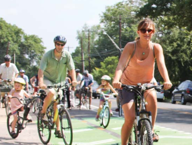
America's Best Bike Network
Completing a network of over 300 miles of protected bike lanes & urban trails.
Cost
$350 million
What this is
Creates an extensive network of bike lanes and urban trails throughout Austin. The network is based on the adopted Bike and Urban Trails Master Plans.
Why this is in the plan
A comprehensive bike network offers one of the most cost-effective options for getting substantial numbers of Austinites to use new sustainable transportation modes instead of cars.
The American cities and towns with the highest bike use range from 7-10% in their daily bike commute rate. While there is a ceiling to how many Austinites will use bikes regularly, investing in bike infrastructure is the bang-for-the-buck option because of how cheap bike capacity is compared to other modes and how fast bikes in their own lanes can move relative to cars stuck in peak-time congestion.
For example, an analysis by the City of Austin compared the cost-effectiveness of the network of protected bike lanes to the MoPac Improvement Project. The city estimated the bike plan would serve 20,000 vehicles per day while the MoPac toll lanes would serve 19,000 vehicles daily and cost about $40 million more to complete.
Protected bicycle lanes provide a physical separation from vehicle traffic through bollards, traffic buttons, or concrete curb. These lanes are also separated from sidewalks to reduce conflicts. According to City surveys, over 55% of our community would ride in protected bicycle lanes, while only 15% of our community is willing to ride in a painted bicycle lane. This is why our plan's investment in protected or bike-only infrastructure will be a powerful catalyst for bike use.
Cost estimate methodology
The original 2014 bicycle master plan identified a 248-mile network of on-street bike lanes and urban trails for funding in the 2014. The most up-to-date staff estimate indicates completing the so-called All Ages and Abilities (AAA) network (which includes all Tier 1 Urban Trails in addition to on-street facilities) would cost $170 million.
$47 million of the $170 million would go towards completing on-street improvements. And $123 million would complete the urban trails.
Given recent costs for City bike infrastructure projects and feedback from bicycle advocates, we assume an average cost of $1 million per on-street mile and $3 million per trail mile.
The Wheel Deal invests an additional $180 million in bike infrastructure. This could fund the following grassroots-inspired investment mix: $70 million for the Congress Avenue Urban Design Initiative, $13 million for the Pleasant Valley Bridge, $20 million for safe bike infrastructure to schools, and $77 million for additional urban trails and/or on-street upgrades.
Together, these investments will ensure Austinites have over 300 miles of bike-focused infrastructure, which represents a "strategic start" to creating America's best bike network.
Policy requirements
The selected on-street segments and trails should be updated to ensure the underlying calculations reflect population and amenity changes since the adoption of the Bike Master Plan.
The overall project portfolio should prioritize projects with the highest expected use, while making reasonable scheduling decisions to support geographic equity in the creation of new bicycle infrastructure.
Resources for further reading
550 New Sidewalk Miles
Boosting walkability to transit, bikes, parks, and schools in every Austin neighborhood.
Cost
$350 million
What this is
The current sidewalk gap outlined in the City's Sidewalk Master Plan is 2,580 miles.
The existing sidewalk infrastructure itemized in the Master Plan is roughly 2,400 miles. Adding 550 miles will powerfully cut the gap in every part of town.
Why this is in the plan
Sidewalk improvements & new pedestrian infrastructure make pedestrian trips more attractive and feed transit use.
They are a very politically popular neighborhood-level amenity. And they are very useful infrastructure for Austinites who might not or can not use commuter-focused transit or bike infrastructure, such as kids, retired elderly residents, and pets.
Our proposal of building 550 new sidewalk miles will be sufficient to build the absent very-high, high, and medium priority sidewalks identified in the Sidewalk Master Plan.
Cost estimate methodology
We use a cost of $635,000 per sidewalk mile, based on the cost estimates in the official Sidewalk Master Plan.
Policy requirements
The existing sidewalk prioritization ranking should be updated to reflect new data and updates to land development regulations.
The sidewalk construction sequence should be reviewed by the City's Equity Office to ensure no part of town has to wait too long for pedestrian improvements.
Repairs and maintenance may be prioritized by staff when it is expected to yield higher mode shift than new construction.
Resources for further reading
Shade Fund
A dedicated fund to improve shade coverage in and around high-use public amenities.
Cost
$10 million
What this is
The new Shade Fund will boost Austin's climate resilience by making existing pedestrian infrastructure and other public amenities more inviting.
Uses would include tree-planting, lightweight shade structure installation, park redesigns, and ceiling additions.
Why this is in the plan
Ask any existing transit- or pedestrian-commuter and they will tell you that shade makes a huge difference. It makes the experience more comfortable.
The prospect of hotter weather also makes shade coverage an increasingly important component of creating resilient infrastructure. That's why Phoenix and Los Angeles are developing shade-focused plans.
Cost estimate methodology
Our draft propusal budgets $1 million per City Council district to provide sufficient funding for shade infrastructure in every part of town.
Policy requirements
New shade infrastructure should prioritize high-use public amenities.
Resources for further reading
Vision Zero
Fixing the next 10 most dangerous road intersections.
Cost
$35 million
What this is
New Vision Zero funds will allow re-engineering of the 10 most dangerous City intersections that are not presently funded.
Why this is in the plan
In general, Vision Zero reduces the physical harm done to humans by car collisions. Re-designing dangerous intersections to eliminate pedestrians, cyclists, and transit vehicles being struck by cars supports our mode shift goal.
Including this provision also creates a balanced plan that offers Austinites that must remain motorists tangible, quick improvements to car infrastructure.
Cost estimate methodology
A per-intersection cost of $3.5 million is used. That number is based on the intersection cost estimate in the City's Vision Zero plan.
Policy requirements
The ten most dangerous City intersections should be prioritized as the default spending focus.
In addition to large-scale intersection re-building, City staff may opt for an opportunistic mix of targeted raised crosswalks, slip lane elimination, signal upgrades, traffic circles, bulb-outs, and kneck downs throughout the City if they are a more productive use of funds.
Vision Zero projects should coordinate with other City transportation projects to stay on-time and on-budget.
Resources for further reading
Value Capture Funds
Capturing the wealth creation effects of new infrastructure investments for the public.
Cost
$100 million
What this is
A land acquisition fund will allow the City to capture the increase in the economic value of land near transportation investments.
A counter-cyclical Transit-Oriented Development (TOD) Fund will help the City purchase or develop affordable housing and other community assets near transit stations.
Why this is in the plan
Austin needs an innovative approach to provide operating support for sustainable transportation modes given limited and inconsistent federal government funding, and the many fiscal constraints placed by the state on local entities.
A land acquisition fund enables Austin to adopt ownership- and joint development-based "value capture". It improves the return-on-investment to taxpayers and affords Austin greater independence from federal and state transportation funding politics.
A TOD fund aligns transit investments with equitable housing and community development efforts.
Cost estimate methodology
The TOD fund size ($50 million) is based on peer funds in Denver and the San Francisco Bay Area.
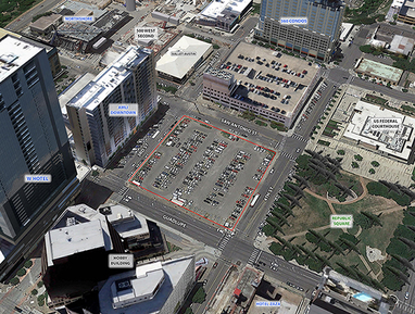
The land acquisition fund size is intended to serve as a pilot for land acquisition-based value capture. We examined the deal at 308 Guadalupe to determine an appropriate pilot fund size.
The County purchased the 308 Guadalupe property for $21.75 million in 2010, which is approximately $25.85 in present-day dollars once we adjust for inflation.
In 2017, the County agreed to lease the property to private corporations in exchange for $430 million over 99 years, or $4.34 million annually.
Our pilot fund ($50 million) provides sufficient funds for the acquisition of square footage comparable to two 308 Guadalupe buildings.
Policy requirements
The City's value capture approach should be comprehensive and also utilize Tax Increment Financing and Public Investment Districts where beneficial. The proposed funds are intended to complement said policy options.
Proceeds from the land acquisition fund should prioritize transit operations
The timing of acquisitions should be counter-cyclical to facilitate buying at discounted prices.